Explore Walpole
ExploreWalpole makes rich and detailed information on Walpole’s geography, flora and fauna, natural and social history readily accessible through the internet using the free Google Earth™ software. It has been developed by the Walpole and Nornalup Districts Historical Society.
The current version contains information on:
- Aboriginal Heritage.
- Early European coastal exploration.
- Early European land-based exploration.
- European settlement.
- The history of the town and its amenities.
- Natural sites and places of interest.
ExploreWalpole grew out of a desire to make the wonderful photographs and historical research held by the Walpole Nornalup and Districts Historical Society in the Walpole Library more accessible to the public.
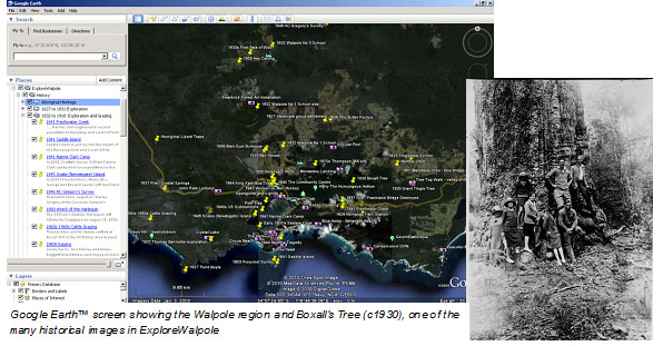
ExploreWalpole is a selection of material from a range of well-researched and authoritative sources that can be tied to specific locations in Google Earth™. The presentation of this material in a geographic format allows you to explore the Walpole region by clicking on points, paths and regions.
Version 1.0 contains 105 sites and includes 75 historical and other photographs.
Using ExploreWalpole
You must have Google Earth™ installed on your computer. This software can be downloaded from http://earth.google.com/. Then click on the link below to start downloading the ExploreWalpole file.
DOWNLOAD ExploreWalpole Public v1.0.kmz (5.09MB)
When the file has downloaded, unzip the file, double-click on it and it will open in Google Earth™. Please refer to Google Earth™ documentation for guidance on using Google Earth™ software.
In the Places pane on the left hand side of the Google Earth™ window you will see a new folder called ExploreWalpole. Expand this folder to see the various subfolders. You can control how many locations are shown on the map by turning these folders on or off. Note that in many areas of the map there are several sites in a small area. Some of these sites will not be visible until you have zoomed to a small scale. We have sought to locate sites as accurately as possible, however many locations are indicative rather than precise. Use caution as well as other cartographic sources and tools if attempting to navigate to some locations, particularly in forest areas.
Feedback, Corrections and Adding Information
ExploreWalpole is managed by Matt Wrigley, of the Walpole Nornalup and Districts Historical Society (WNDHS). We expect that this prototype will expand to include more information and sites over time. Existing entries will be improved and refined. You can assist us in this process by:
- Letting us know of inaccuracies or errors
- Composing your own entries for new sites or expanding on existing entries
- Suggesting amendments to entries
We would also appreciate general feedback on your use and experience of ExploreWalpole. Please email Matt at mwrigley@westnet.com.au.
Thanks to Lee and Geoff Fernie, Gary Muir, Lee Hunter, Caroline Aggiss, Julie Ewing and the members of the WNDHS for their assistance.